Alpine Escape: When My Phone Saved the Journey
Alpine Escape: When My Phone Saved the Journey
Sweat trickled down my temples as I white-knuckled the steering wheel on that godforsaken mountain pass. What should've been a glorious August drive through the Bernese Oberland had devolved into a sweltering metal coffin trapped behind endless caravans. My vintage Volvo's AC wheezed its last breath just as festival traffic swallowed Route 11 whole - thousands of techno pilgrims crawling toward some alpine rave. Horns blared like angry geese, exhaust fumes stung my eyes, and panic coiled in my gut like overheated engine cables. That's when the miracle happened.
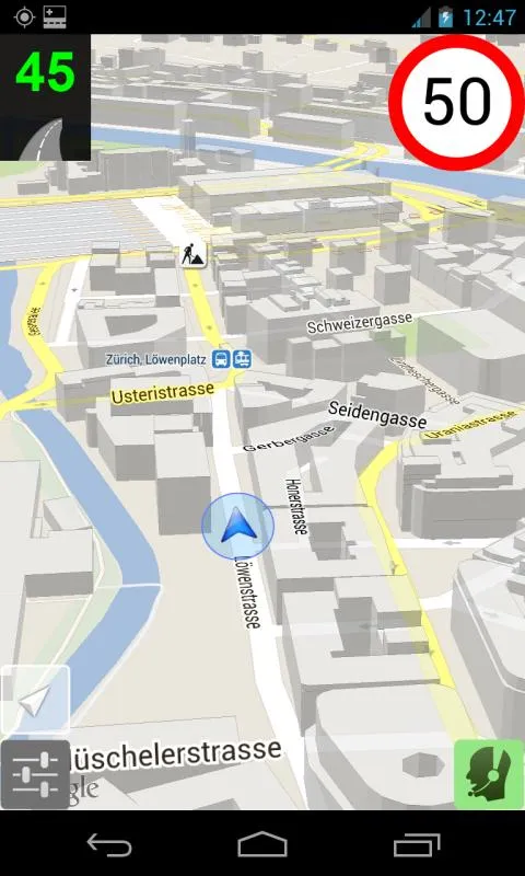
A soft chime cut through the chaos - that familiar three-tone alert from my dashboard phone mount. "Road closure ahead at Interlaken West," announced the calm digital voice I'd come to trust. Swiss-Traffic's interface glowed with angry crimson lines where my planned route disintegrated. But before my curse fully formed, emerald arrows bloomed across the screen like alpine wildflowers, charting an escape through backroads even Google couldn't fathom. "Turn left in 200 meters onto unpaved service road," it instructed, and I obeyed like a sinner grasping salvation.
The transformation felt biblical. One moment choking on diesel fumes, the next coasting down a single-lane track where cows outnumbered cars. My open window gulped pine-scented air as we skirted turquoise lakes untouched by tourist hordes. That's when I noticed the magic - no cell signal for miles, yet the app's topographic maps rendered flawlessly. Later I'd learn its secret: vector-based cartography that stores entire countries in mere megabytes, updating silently whenever it sniffs WiFi like some digital truffle pig. Pure witchcraft compared to those data-guzzling monstrosities that fail you at the first tunnel.
But this lifesaver nearly got me killed last spring. Remembering that icy misadventure near Davos still tightens my shoulders - Swiss-Traffic cheerfully routing my sedan up a "shortcut" that turned out to be a snowcat trail narrower than a goat path. Terrifying minutes reversing downhill with tires skittering over shale while the app chirped "recalculating" like some demented cuckoo clock. Today though? Flawless. As we descended into Lauterbrunnen Valley, it warned of cyclists before they materialized around blind curves, crowdsourced hazard alerts pinging from other drivers' phones like digital guardian angels. When a tractor suddenly backed out of a barn, my phone vibrated with urgency milliseconds before my eyes registered the danger.
Watching dusk paint the Eiger crimson, I finally understood this tool's brutal elegance. Unlike those chirpy navigation apps treating every trip like a game, Swiss-Traffic respects Swiss roads' lethal poetry. Its silence between instructions speaks volumes - no inane chatter about petrol stations or speed traps. Just cold, precise data flowing from cantonal traffic centers blended with predictive congestion algorithms that learn from millions of anonymized journeys. The UI stays brutally minimal too - no cartoonish icons or dopamine-triggering gamification. Just survival-grade information served without garnish.
Parking at the trailhead, I killed the engine to absolute silence. No engines, no horns - just cowbells echoing up the valley. My knuckles finally unclenched from the wheel. That little red icon on my phone had transformed a potential road rage incident into something sacred. I traced the glowing route on the screen - 47 kilometers of backroad genius avoiding every traffic snarl. For the first time all day, I laughed aloud. Take that, you overpriced festival tickets and diesel-choked highways. My co-pilot rides shotgun in the cloud.
Keywords:Swiss-Traffic,news,alpine navigation,real-time routing,offline maps


