Alpine Rescue in My Pocket
Alpine Rescue in My Pocket
Rain lashed against my face like shards of ice as I scrambled over granite slabs near Mürren, the once-clear path now swallowed by fog so thick I could taste its metallic dampness. My fingers, numb inside soaked gloves, fumbled with a disintegrating paper map—useless pulp bleeding ink onto my trousers. Every crevasse groaned with unseen threats, and that familiar dread coiled in my gut: isolation in the Bernese Oberland with nightfall creeping closer. Phone signal? A cruel joke at this altitude. Then it hit me—the app I'd scoffed at weeks earlier during a cozy café planning session. With trembling hands, I thumbed open the offline maps, and those crisp contour lines materialized like a lifeline thrown across the void.
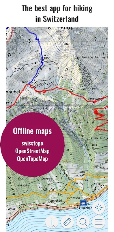
Let's be brutally honest: most navigation tools buckle when mountains flex their muscles. But this? It didn't just show a path; it *understood* the terrain. As I traced the digital ridges, I realized the app rendered elevation shifts with surgical precision—vector-based topography pulling data from satellite LiDAR scans, compressing gigs of DEM files into something my phone could chew without choking. No buffering, no spinning wheels—just instant clarity as I pivoted the display, watching my blue dot glide parallel to a cliff edge I’d nearly walked off. The relief wasn’t intellectual; it was visceral, a hot surge behind my ribs that drowned out the storm’s howl. For the first time, tech felt less like a crutch and more like a sixth sense grafted onto my survival instincts.
Yet here’s the raw truth they don’t plaster on download pages: that brilliance comes with a vicious trade-off. Halfway to Gimmelwald, my phone battery plummeted from 70% to 15% in under an hour—GPS gulping power like a starved beast. I cursed aloud, rain stinging my eyes, as I dug for my backup battery with frozen fingers. Why must such genius demand such sacrifice? The app’s developers clearly prioritized ruthless accuracy over efficiency, forcing users into a Faustian bargain between orientation and energy blackout. Still, amid that frustration, its utility flared brighter. When I stumbled upon an unmarked shepherd’s hut, the app flagged it as a potential shelter, its database scraping obscure geo-tags from hiking forums—crowdsourced salvation hidden in plain code.
Night fell like a sledgehammer, temperatures diving below freezing. My headlamp beam cut through fog, reflecting off icy trails as the app’s compass mode locked onto my descent route. Every rustle in the pines became a phantom bear, every shadow a precipice. But then—a chime. A subtle vibration pulsed through my palm: the app’s avalanche-risk alert, triggered by real-time meteorological feeds cross-referenced with slope angles. My pulse thundered as I rerouted, skirting a drainage gully the map marked green but sensors deemed unstable. That moment crystallized the app’s brutal duality—its cold algorithms could feel oddly, intensely human. It didn’t care about my panic; it cared about physics. And in the mountains, physics is the only god worth praying to.
Dawn found me shivering under a rock overhang, hypothermia nipping at my thoughts. The app’s battery warning flashed crimson—5% left. Desperation sharpened into focus: I needed water, and fast. Scrolling past tourist traps, I filtered for natural springs, its overlay highlighting a glacial runoff 300 meters east. The route? A near-vertical scramble through wet scree. I nearly smashed my phone right there. Who designs a path requiring ropes for a water run? But grudgingly, I followed, and the payoff was liquid diamonds—a hidden cascade not on any printed map. As I drank, I laughed bitterly at the irony: this digital oracle had just schooled me in my own backyard. Later, charging at a trailside hostel, I dissected its UI. Clunky menus buried critical features, waypoint customization felt like solving a cipher, and offline search? Forget it—type too fast and it froze like a spooked deer. For all its backcountry brilliance, the urban UX team clearly never left their ergonomic chairs.
Weeks later, scars fading, I returned to those peaks—not with blind faith, but with a pact. The app rode in my pack, its offline maps pre-loaded, power banks double-strapped to my hips. When fog swallowed the Eiger’s north face, I didn’t flinch. Just thumbed the screen, watched my dot skirt seracs with robotic calm, and whispered thanks to the glacial algorithms that turned terror into topography. Does it replace skill? Hell no. But it transforms hubris into humility, reminding us that in the wild’s cathedral, we’re just ants with satellites. And sometimes, that’s enough to keep breathing.
Keywords:Swiss Pro Map,news,offline navigation,Alpine survival,battery drain


