City Trails Captured Forever
City Trails Captured Forever
The cobblestone alley glistened under a sudden downpour, rain distorting the warm glow spilling from a hidden bookstore window. I snapped a hurried photo, already dreading the inevitable: another nameless gem swallowed by London’s labyrinth. Weeks later, staring blankly at my gallery, that perfect alleyway was just "IMG_4721". It wasn’t just lost geography; it felt like a piece of the moment’s magic had evaporated. My meticulous travel notes couldn’t compete with the sheer volume of forgotten corners.
A Pinpoint Revelation
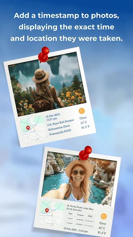
Then came GPS Camera Photo With Location. Skepticism battled curiosity as I downloaded it – another gimmick? Opening the app felt jarringly simple. No splashy tutorials, just an immediate overlay on my native camera view: bold latitude/longitude coordinates, a crisp timestamp, and a tiny sun icon promising weather data. The real hook? The data wasn’t slapped on later; it was woven into the image’s EXIF metadata at the instant of capture. This wasn’t just decoration; it was embedding the scene’s DNA. My first test shot of a rain-slicked pub sign near Embankment carried "51.5074° N, 0.1224° W, 14:23, Light Rain, 12°C". Suddenly, that anonymous pub had an anchor. The relief was visceral, like finding a map after being hopelessly lost.
Urban Archaeology Unleashed
My weekend wanders transformed into digital archaeology digs. That brutalist concrete monstrosity I found oddly beautiful? Tagged instantly: "Southbank, Overcast." The absurdly tiny blue door tucked away in Mayfair? "Sunny, 18:05." The app’s offline functionality became crucial underground on the Tube or deep in signal-dead parks; it cached location via GPS satellites, injecting the data later once connectivity resumed. This technical resilience felt empowering. I wasn’t just taking pictures; I was meticulously cataloging the city’s pulse, one geotagged frame at a time. Sharing these photos became a revelation too. Friends didn’t just ask "Where is this?" – they demanded specifics based on the embedded data. "That drizzle looks miserable near Regent’s Canal!"
The Bite of Reality
But the honeymoon phase hit snags. God, the battery drain! A three-hour walk hunting street art in Shoreditch turned my phone into a useless brick. The app’s constant GPS polling and real-time data fetching was a vampire. Planning required portable chargers – an annoying tax on spontaneity. The UI, while functional, occasionally felt clunky. Accidentally triggering the "custom text stamp" instead of the weather icon mid-shot led to frustrating do-overs. And privacy… a sharp, cold realization hit when I almost shared a photo tagged precisely outside my flat. The app desperately needs granular location obfuscation for sensitive shots – blurring coordinates or disabling stamps per image. Trust eroded slightly that day.
Moments Frozen, Not Lost
Despite the grit, the core magic persists. Finding an old photo tagged "Hyde Park, Heavy Fog, 7:02 AM" instantly replays the crunch of frost underfoot and the eerie silence before the city woke. It’s more than metadata; it’s a sensory key. GPS Camera Photo isn’t perfect – its hunger for power is infuriating, and privacy controls are dangerously naive – but its fundamental promise is delivered. My urban explorations are no longer fleeting impressions; they are meticulously pinned moments in time and space, resistant to the erosion of memory. The city’s soul, once elusive, now lives firmly within the pixels and coordinates.
Keywords:GPS Camera Photo With Location,news,urban exploration,geotagging,digital memory


