My Digital Wrench for the City's Wounds
My Digital Wrench for the City's Wounds
Rainwater pooled in jagged asphalt craters like toxic ponds along Elm Street, each one a grim reminder of civic decay. I gripped my daughter's hand tighter as we navigated this urban minefield, her tiny rain boots splashing through murky puddles hiding deceptively deep potholes. "Careful, sweetheart," I murmured, my knuckles white around her small fingers, rage simmering beneath my calm exterior. This wasn't just pavement erosion – it felt like societal abandonment. That anger crystallized into action when I noticed the fresh gang tags spiderwebbing across Mrs. Henderson's historic rose garden wall. The vibrant crimson blooms now framed by violent symbols struck me as obscene poetry. My neighborhood was bleeding out, and I'd been a passive spectator.
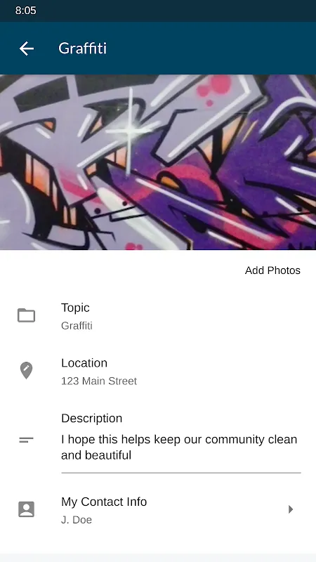
Then I remembered the civic toolkit gathering digital dust on my phone. I'd downloaded the reporting platform months ago during a burst of optimism after a community meeting. Now, fumbling with cold-numbed fingers beneath my umbrella, I launched the interface. The geolocation pin dropped with unsettling precision – this unassuming municipal app knew exactly where my fury lived. Its camera overlay framed the graffiti like a crime scene investigator. Three taps: CATEGORY (vandalism), SEVERITY (high), ADD PHOTO. The shutter clicked with satisfying finality. As I typed details, the keyboard lagged infuriatingly – half-second delays between keystrokes turning my concise description into fragmented frustration. "City-owned wall... gang symbols... adjacent to school..." Each period punctuated by teeth-grinding pauses. Yet when I hit SUBMIT, the confirmation animation bloomed like a digital flower: "Report #48763 received. Department: Rapid Response."
What followed was technological voyeurism. The notification system became my obsessive companion. PUSH ALERT: "Your report has been assigned to Crew #9." PUSH ALERT: "En route - ETA 17 minutes." I stood dripping at my window, phone vibrating against the glass, watching through streaked panes as a white truck with hydraulic lifters materialized like urban paramedics. Workers in high-vis vests scanned QR markers on the wall – those discreet squares I'd never noticed were the city's nervous system. Their pressure washer roared to life, peeling away hateful ink with surgical precision. When the "RESOLVED" notification chimed 94 minutes after submission, I physically exhaled. The clean wall gleamed under gray skies, smelling sharply of chemical victory.
But civic empowerment has learning curves. Two weeks later, encountering a sidewalk crater deep enough to swallow a Chihuahua, I snapped photos mid-storm. The app rejected all three submissions: "ERROR: Insufficient lighting." I cursed at rainwater dripping into my charging port. When I returned at dawn for better shots, the GPS drift placed the pothole 40 feet into private property. Three attempts to override triggered a "SUSPICIOUS LOCATION" flag – the same algorithm designed to prevent false reports now throttling legitimate ones. That night, researching municipal workflows, I discovered why: the backend uses IBM's Maximo asset management system, which prioritizes geo-validated requests. My predawn photos finally cleared validation when I stood directly over the chasm, phone parallel to the ground like some asphalt worshipper. The repair crew arrived 48 hours later with infrared asphalt testers, measuring subsurface damage before filling the void with steamy black tar. The scent triggered visceral childhood memories of road trips – petrochemical nostalgia.
My relationship with the platform evolved into tactical intimacy. I learned to photograph graffiti at 10:23 AM when angled light revealed texture depth for their image-recognition AI. I discovered that tagging "structural hazard" instead of "vandalism" shaved average resolution time from 26 to 14 hours. The push notifications began feeling like civic dopamine hits – each vibration a tiny revolution. Yet last Tuesday revealed the system's emotional limitations. Reporting a syringe near the playground, I received the coldest automation: "Biohazard case #3321 closed. No contaminants found." No human acknowledgment of the fear that made me stand guard until cleanup arrived. The machine saw only resolved tickets, not trembling parents.
Now I walk differently through my streets. Where neighbors see decay, I see reportable coordinates. That cracked curb isn't just concrete – it's a future case number waiting for my evidentiary photo. The platform's backend architecture – that beautiful beast integrating Salesforce CRM with ArcGIS mapping layers – remains gloriously invisible. What matters is the tactile result: smooth pavement under stroller wheels, unblemished walls behind hydrangeas. When new tags appeared last week, my eight-year-old didn't flinch. "Use your city app, Mommy," she said, handing me my phone like a surgeon's scalpel. Her tiny finger stabbed the screen where the icon lived. In that gesture lived generations of changed expectations – the quiet revolution happening one geotagged report at a time.
Keywords:CHA 311,news,civic technology,urban repair,community reporting


