My Heart Pounded as Borders Blurred
My Heart Pounded as Borders Blurred
I remember the crisp autumn air biting at my cheeks, the crunch of fallen leaves under my boots echoing in the silent Montana wilderness. It was my third day hunting mule deer, and I was deep in territory I'd only scouted on paper maps back home. The sun was beginning to dip below the jagged peaks, casting long shadows that played tricks on my eyes. I'd been tracking a decent buck for hours, my focus so intense that I barely noticed how far I'd wandered from my known landmarks. Suddenly, I froze—a wire fence appeared ahead, partially hidden by brush. My stomach clenched. Was this someone's private land? Last year, a buddy got fined for accidental trespassing, and the memory haunted me. I fumbled for my phone, fingers numb with cold and anxiety, and opened the app that would change everything.
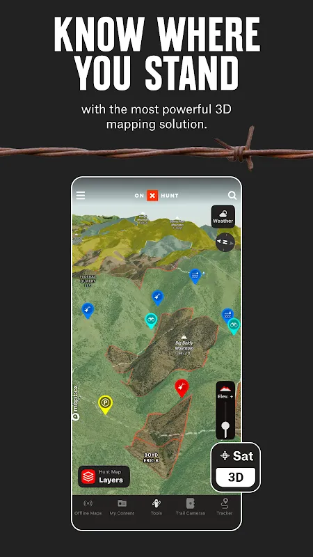
onX Hunt loaded almost instantly, the map rendering in vivid detail despite the spotty cell service out here. I'd downloaded the offline maps beforehand, a feature I'd scoffed at as overkill during setup but now praised silently. The screen showed my exact location as a pulsating blue dot, overlayed with colorful property boundaries that glowed like neon signs in the dimming light. National forest land shaded in green, BLM areas in yellow, and private parcels outlined in stark red. I zoomed in, holding my breath, and saw that the fence line matched perfectly with a private property boundary. Relief washed over me so intensely that I nearly laughed aloud. I wasn't just avoiding a fine; I was hunting ethically, responsibly, and that felt damn good.
The Technology Behind the Trust
What makes this app stand out isn't just the map—it's the precision of the underlying tech. onX Hunt uses a combination of GPS, GLONASS, and satellite data to achieve accuracy within a few meters, even in remote areas where other apps fail. I learned this the hard way last season when a cheap navigation tool led me astray, adding hours to my trek. Here, the geospatial algorithms update in near-real-time, accounting for elevation changes and terrain obstacles. While using it, I noticed how smoothly it handled battery-draining tasks; the developers clearly optimized for energy efficiency, allowing me to track my route for hours without my phone dying. But it's not perfect—sometimes the property data lags, especially after recent land sales, and I've had moments of doubt when boundaries didn't match new fencing. That's where the crowd-sourced updates come in; users can report discrepancies, and I've contributed a few times, feeling like part of a community rather than just a consumer.
One afternoon, as rain began to drizzle, I relied on the app's weather overlay feature, which pulled data from local stations to show storm patterns moving in. It predicted a window of clear sky, giving me confidence to push deeper into a valley where I eventually bagged my buck. The tactile feedback of tapping waypoints, the auditory alerts when I neared a boundary—it all fused into an immersive experience that blurred the line between digital tool and instinct. I found myself trusting it more than my own sense of direction, which was both empowering and slightly unnerving. There were glitches, though; once, the app crashed mid-navigation, leaving me disoriented for a panicked minute until reboot. It reminded me that technology is fallible, and I should always carry a physical compass as backup.
A Moment of Raw Emotion
The climax came when I was pursuing a trophy elk in Wyoming's rugged backcountry. I'd spent days studying topo maps and marking potential spots on onX Hunt, but nothing prepared me for the adrenaline rush of the actual chase. As I crested a ridge, the app's boundary alert vibrated softly—a gentle nudge that I was approaching private land. I paused, heart racing, and watched a massive bull elk graze just yards away, safely on public ground. The satisfaction was visceral; I took the shot cleanly, and in that moment, the app felt less like software and more like a hunting partner. It had given me the confidence to stay legal and ethical, amplifying the joy of the harvest without the guilt of potential trespass.
Reflecting on seasons past, I've come to appreciate how onX Hunt has evolved. The latest update introduced 3D mapping, allowing me to visualize terrain in a way that feels almost cinematic. Yet, it's the small details—like the ability to measure distances between points or save favorite spots with custom notes—that make it indispensable. I've cursed it when it drained my battery faster than expected on cold days, but I've also praised it when it guided me out of a whiteout blizzard using saved routes. This emotional rollercoaster—frustration, relief, excitement—is what makes it real. It's not a perfect app; the subscription cost stings, and the interface can be clunky for newcomers, but for someone who lives for the hunt, it's worth every penny and every swear word muttered at its occasional failures.
In the end, onX Hunt has reshaped my approach to hunting, blending tradition with technology in a way that feels natural. It hasn't replaced skill or instinct; it's augmented them, making me a better, more conscientious outdoorsman. As I pack for next season, I feel a mix of anticipation and gratitude—for the wild places, the challenges, and the digital companion that helps me navigate them all.
Keywords:onX Hunt,news,hunting navigation,outdoor technology,ethical hunting


