Subway Savior: When NYC's Chaos Met My Phone
Subway Savior: When NYC's Chaos Met My Phone
You haven't truly lived New York City panic until you're sprinting down Lexington Avenue at 8:47 AM, dress shoes slipping on wet pavement, while your brain screams two irreconcilable truths: this client meeting cannot be missed and the E train is actively betraying you. That particular Tuesday morning, humidity clung to my suit like plastic wrap as I crashed through the turnstile, eyes frantically scanning the platform. Where was the damn train? The ancient LED sign flickered "3 MIN" - a notorious liar in MTA folklore.
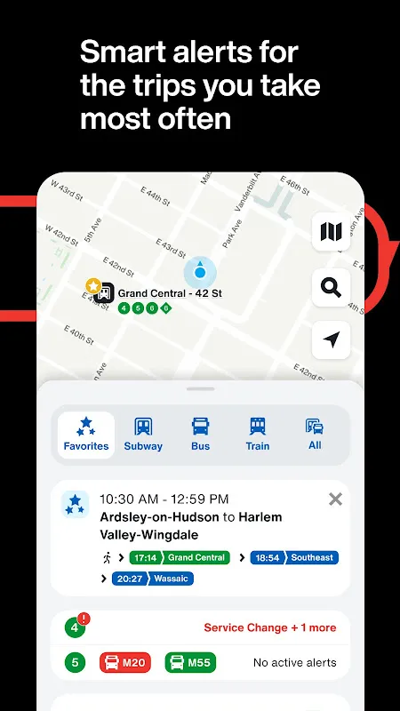
My thumb jammed against the phone screen still damp with rain. The MTA app bloomed to life not with static schedules, but with pulsing blue lines snaking underground. There it was - my phantom E train, crystallized as a tiny digital bead crawling toward 53rd Street. But the revelation wasn't just its location; it was the scarlet "DELAYED" badge flashing next to it, with a granular explanation: "Signal Problems at Roosevelt Ave." In that moment, the abstraction of "train trouble" became visceral. I could almost hear the screeching metal, smell the ozone. That crimson alert wasn't just data - it was permission to stop running.
What followed felt like urban witchcraft. A single swipe revealed the orange glow of the B line approaching just one platform over. Not ideal, but viable. The app calculated my new path as I moved: transfer at 42nd, walk two blocks, arrive 9 minutes late with apologies ready. That algorithmic lifeline didn't just reroute trains - it rewired my panic into purposeful strides. When I stepped onto that B train, its familiar rattle sounded like victory. Other commuters still craned necks, haunted by uncertainty. I stood anchored, phone in hand, suddenly fluent in the city's secret language.
Later, I'd learn to appreciate the technical ballet behind that moment. The app doesn't just scrape schedules - it ingests thousands of GPS pings from trains and buses, cross-references them with track sensor data, and factors in historical delay patterns. That "DELAYED" tag? An algorithm weighing 14 variables including passenger load metrics and track circuit occupancy. Yet what matters underground isn't the machine learning - it's the visceral relief when your palms stop sweating because a machine understands concrete problems.
Of course, it's not perfect. Some evenings when the app claims a train is "ARRIVING" while you stare at empty tracks, you want to hurl your phone onto the third rail. And woe betide anyone relying solely on its bus predictions during Manhattan gridlock - watching your digital bus icon freeze mid-block as rain soaks through your shoes is a special kind of hell. But these failures sting precisely because the app usually works with such eerie precision. You grow accustomed to its intelligence, making the occasional glitch feel like betrayal by a trusted friend.
Now, I navigate differently. I notice how tourists still cluster around static maps, fingers tracing colored lines like medieval scholars puzzling over astrolabes. Meanwhile, locals glide through turnstiles with phones angled downward - not texting, but consulting their real-time compass. The rhythm of my commute syncs to app vibrations: a subtle buzz means the F train is approaching Atlantic Terminal; two pulses warn of weekend service changes. This digital tether transforms the subway from a stressor to a system I command. When visitors ask how I tolerate NYC transit, I show them my screen. Not the city that never sleeps, but the city that constantly transmits.
Keywords:MTA Official App,news,real-time transit,subway navigation,urban mobility


