When My Phone Named the Alps
When My Phone Named the Alps
Fog swallowed the trail like cold cotton wool, each step forward feeling like betrayal. My knuckles whitened around my trekking pole while condensation dripped from my eyebrows – another glorious Chamonix morning where visibility ended at my nose. I’d gambled on clearing skies for this ridge traverse, but Mont Blanc’s moods are crueler than a jilted lover. Panic bubbled when a rock outcrop I’d sworn was my landmark dissolved into nothingness. This wasn’t adventure; it was geographical blind man’s bluff with avalanche chutes for penalties.
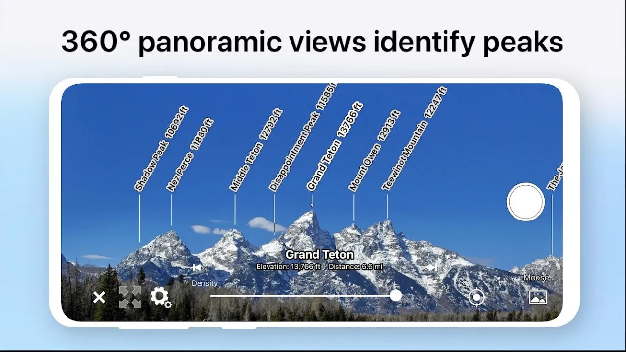
Fumbling with frozen fingers, I triggered AR AlpineGuide. The screen flickered, mist swirling across its surface until contour lines and peak names burned through the gloom like neon rescue flares. Suddenly, the Aiguille du Midi’s fang-like silhouette materialized 45 degrees left, tagged with its 3,842m altitude in crisp white text. To the right, Le Dent du Géant’s jagged crown emerged from the soup, its distance dynamically shrinking as I shuffled closer. The mountains weren’t hiding anymore – they were introducing themselves through my cracked iPhone screen.
What witchcraft made pixels override pea soup fog? Later, guides explained the brutal elegance behind it: combining phone gyroscopes, accelerometers, and GLONASS satellite signals with topographic databases. But in that moment, it felt like sorcery. As I rotated slowly, compass bearings overlaid on live camera feed while real-time wind speed data flashed warnings near exposed cornices. When I tilted toward a shadowy mass, elevation profiles unfurled like ribbon candy – revealing that "shortcut" was actually a 70-degree ice slope. AR AlpineGuide didn’t just identify peaks; it translated the mountain’s snarling dialect into survival English.
Yet the magic had thorns. That glorious augmented reality? A battery vampire draining 20% in ten minutes. The precision I worshipped required absurd calibration dances – arms outstretched, spinning like a demented weathervane while fellow hikers smirked. And god help you if clouds thickened beyond 90% opacity; the app would stubbornly display phantom peaks like a drunk cartographer. Once, it insisted a nearby boulder was Mont Maudit’s summit ridge, nearly luring me off a cliff. You don’t trust technology here; you interrogate it between prayer beads.
Descending into Vallée Blanche at twilight, I paused as alpenglow ignited the glaciers. Raising my phone, AR AlpineGuide painted the scene with invisible ink: naming seracs, tracing historic climbing routes up the Grandes Jorasses, even overlaying the retreat path of Bossons Glacier since 1820. History and hydrology bloomed across the ice. That’s when it struck me – this wasn’t navigation. It was time travel. The mountain whispered its autobiography through layered data ghosts only my screen could see, turning a silent descent into a geological TED Talk.
Back at the refuge, climbers snorted at my "digital crutch." But when dawn revealed fresh powder obscuring the normal route? Suddenly they’re begging to borrow my "peak finder thing." I watched a Czech alpinist gasp as it identified the obscure Aiguille du Tacul summit through blizzard conditions – his wonder mirroring mine days prior. AR AlpineGuide’s true power isn’t just naming mountains; it’s transforming arrogance into humility. You realize how little you truly see until technology lifts the veil. Though next time? I’m duct-taping a power bank to my helmet.
Keywords:AR AlpineGuide,news,augmented reality navigation,mountain safety,Alps trekking


